 Filter: Categories of Wisconsin Historical Images
Filter: FORMAT_DIMENSIONS of 47 x 54 cm.
Filter: Categories of Wisconsin Historical Images
Filter: FORMAT_DIMENSIONS of 47 x 54 cm.

| Date: | 1859 |
|---|---|
| Description: | This 1859 map of Washington County, Wisconsin, shows the township and range grid, towns, sections, landownership and acreages, cities and villages, roads, ... |
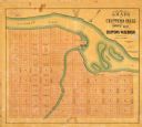
| Date: | 1800 |
|---|---|
| Description: | This map of Chippewa Falls is a lithograph and shows plats, labeled streets, landings, some businesses, and the Chippewa River. The map was drawn "from act... |

| Date: | 1746 |
|---|---|
| Description: | Detailed map of the western hemisphere and part of Africa and Europe. Islands, cities, settlements, rivers, lakes, countries, and regions are marked. Mount... |
If you didn't find the material you searched for, our Library Reference Staff can help.
Call our reference desk at 608-264-6535 or email us at: